Updated April 15, 2026: Section Closure & Detour Advisory: as of April 14, 2025
The Torbay Harbour Authority has advised of a long-term closure of public access to Tapper’s Cove starting Monday, April 14, 2025, for major reconstruction of the wharf and breakwater. The length of closure is undetermined, and may last until Spring 2027. As a result, the Father Troys Trail section through Tapper’s Cove is closed until further notice.
A 1km detour around the area is in place:
- Northbound hikers (towards Flatrock): Detour via Dunphy’s Lane → Charles Lane → Morris Avenue → rejoin the trail.
- Southbound hikers (towards Torbay): Detour via Morris Avenue → Charles Lane → Dunphy’s Lane → rejoin the trail.
Signage for the closure and detour is posted on the path. Read the full notice here.
The East Coast Trail Association asks hikers to please respect all closure signage.
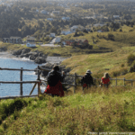
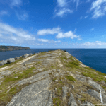
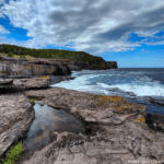
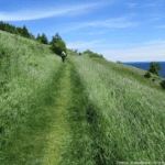
This path follows a historic route connecting Torbay and Flatrock, with attractions including dramatic cliff views, a side trail loop deep into a cove to view a thriving kittiwake colony, and a community road dating to the 1820s. The trail passes a stony beach at Torbay, Tappers Cove wharf and mural, Church Cove loop, and a rocky jut of land known as the Beamer. Alternative routes at Church Cove offer the gentler inland route, as well as the difficult coastal ascent or descent of 125 m, partially on exposed rock steps. Note, in slippery conditions it is advised to by-pass the Beamer, Church Cove Point, and Church Cove Loop. Exercise caution near high cliffs. There are services available in Torbay; however, there are limited facilities in Flatrock.