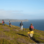
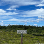
Cape Spear Path

Newfoundland and Labrador Tourism

14. Mickeleens Path

All Paths

Route:
Bay Bulls to Witless Bay
Current Path Status:
Open, Caution

All Paths

Current Path Status:
Open, Caution
Route:
Bay Bulls to Witless Bay
About This Path:

This path wanders through peaceful woods alternating with tramps across lush sea meadows and visits to cliff edge vantage points overlooking impressive coves, nesting guillemots, passing cormorants, sea stacks, gulches, red sandstone cliffs, whales, offshore islands, and the Witless Bay Islands Ecological Reserve. In the fall, look for dramatic wave action along the coast. Facilities and services can be found in both Bay Bulls and Witless Bay.

Witless Bay Community Walk Detour – Mickeleens Path – Map No. 14
August 18, 2025

There is a bridge (Perry’s Brook) closure at the intersection of Deans Road and Harbour Road in Witless Bay beginning August 18. The closure is necessary to facilitate bridge rehabilitation work. The bridge is anticipated to remain closed until November 11 2025. Pedestrian access is not permitted during the closure. Hikers coming from the North will need to turn right onto Deans Road (for 1.2km), turn left onto North Side Track Road (for 1.2km), turn left onto Jockey’s Lane (for 190m) and rejoin Harbour Road to continue the community walk along Harbour Road, for a total detour of 2.6km (35 minute walk). Hikers from the South will need to turn left onto Jockey’s Lane, right onto North Side Track Road and right onto Deans Road and rejoin at the intersection of Harbour Road and Bears Cove Road. Motorists are asked to pay attention to traffic control, follow detour signage and be prepared to slow down. Information on active highway construction projects and repairs is also available by visiting nl511.ca and on the NL 511 mobile app.

Length
7.2km
Estimated time
2 Hours to 4 Hours
Difficulty

 MODERATE

Path Advisory: Trail structures & the trail bed along Mickeleens Path requires repair. Hikers will encounter greater than normal areas of wet and muddy trail and deteriorated trail structures. An assessment of these paths is ongoing, and work will be scheduled based on funding availability. Please use extra caution when hiking. No path clearing or conditions updates take place during winter months. Map recommended. Trail-rated footwear required.
Access Points:
  • Bay Bulls - Drive to the end of Quays Road. Park on the shoulder of the turnaround, at the end of the pavement. Continue for 280 m along the cart track to the trailhead.
  • Witless Bay - Turn left onto Deans Road, near the junction of Highway 10 and 13 (Witless Bay Line). At the end of Deans Road, turn right 50 m, and park at the Witless Bay Seabird Ecological Reserve Tourist Information Centre. Walk 900 m east along Bears Cove Road to the trailhead, located at the school bus turnaround. Do not park in the turnaround.

Community Walk Getting to Beaches Path: After exiting the trail from the Witless Bay trailhead, proceed 800 m along Bears Cove Road, then 1.2 km along Harbour Road. Follow Long Beach for 100 m, then Highway 10 for 300 m, then Lower Loop Road for 300 m, and then Gallows Cove Road for 1.9 km to the Beaches Path trailhead (total: 4.6 km). Witless Bay Community Walk Detour – Mickeleens Path – Map No. 14 August 18, 2025 There is a bridge (Perry’s Brook) closure at the intersection of Deans Road and Harbour Road in Witless Bay beginning August 18. The closure is necessary to facilitate bridge rehabilitation work. The bridge is anticipated to remain closed until November 11 2025. Pedestrian access is not permitted during the closure. Hikers coming from the North will need to turn right onto Deans Road (for 1.2km), turn left onto North Side Track Road (for 1.2km), turn left onto Jockey’s Lane (for 190m) and rejoin Harbour Road to continue the community walk along Harbour Road, for a total detour of 2.6km (35 minute walk). Hikers from the South will need to turn left onto Jockey’s Lane, right onto North Side Track Road and right onto Deans Road and rejoin at the intersection of Harbour Road and Bears Cove Road. Motorists are asked to pay attention to traffic control, follow detour signage and be prepared to slow down. Information on active highway construction projects and repairs is also available by visiting nl511.ca and on the NL 511 mobile app.
Amenities
Parking
Features
Bird Nesting
Cliff
Coastline Views
Developed Trail
Ecological Reserve
Gulch
Heath
Island View
Knoll
Meadow
Sea Stack
Woodland