Cape Spear Path

Newfoundland and Labrador Tourism

15. Beaches Path

All Paths

Route:
Witless Bay to Mobile
Current Path Status:
Open

All Paths

Current Path Status:
Open
Route:
Witless Bay to Mobile
About This Path:

This path brings you on a peaceful walk close to the shoreline, following the sea edge with mild elevation changes, and many views of offshore islands. The path weaves through woods, heath, and meadowland. Cobblestone beaches are accessible at many points. Witless Bay Ecological Reserve should be noted for migratory seabird and puffin nesting habitat. The south section of the path from Mobile Point to Mobile Beach has more uneven treadway and hilly sections than the north end of the path. Note, Beaches Path is subject to erosion by ocean currents. Facilities and services are available in Witless Bay. Facilities in Mobile are limited.

Length
7.1km
Estimated time
2 Hours to 3 Hours
Difficulty

 EASY

Path Advisory: No path clearing or conditions updates during winter months. Map recommended. Trail-rated footwear required.
Access Points:
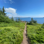
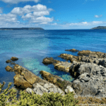
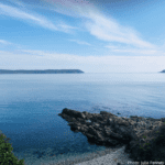
  • Witless Bay - Turn left onto Lower Loop Road. After 300 m, turn left again onto Gallows Cove Road. Follow the road for 1.8 km to the parking area and turnaround at Ragged Beach. Cross a 60 m stretch of cobblestone beach to the trailhead.
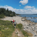
  • Mobile - Park at the Mobile Central High School. Cross Highway 10 and walk down the short lane to Mobile Beach.

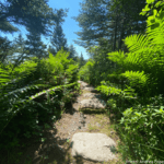
Community Walk Getting to Tinkers Point Path: After exiting the trail from the Mobile trailhead, follow the fenced lane 70 m to Highway 10. Turn left. After crossing the river, turn left onto Gus O'Riellys Road fo 600 m, and continue along the coast on Lower Road for 150 m. A short side trail leads to Rattling Gulch and Scoggins Point. Turn uphill to the junction with Cod Seine Cove Road. Turn left and proceed 200 m to the Tinkers Point Path trailhead (total: 1.1 km).
Amenities
Parking
Features
Beach
Developed Trail
Heath
Meadow
Tuckamore
Woodland