Cape Spear Path

Newfoundland and Labrador Tourism

19. Brigus Head Path

All Paths

Route:
Brigus South to Admirals Cove
Current Path Status:
Open

All Paths

Current Path Status:
Open
Route:
Brigus South to Admirals Cove
About This Path:

This path’s main attractions include Brigus South, a side trail to Turtle Island, the Hares Ears rock formation at Hares Ears Point, and high cliff views around Brigus Head. Herring Cove Beach is sandy, and can be reached with caution; however, it is a hard scramble back up to the trail. Tar Cove has a cobblestone beach; however, the meadow is usually too wet for picnicking. During June and July, visiting finback, humpback, and minke whales circle Brigus Bight, using their natural net shape to trap caplin. Limited facilities are available in Brigus South. Facilities and services are available in Cape Broyle (opposite Admirals Cove).

Length
6.4km
Estimated time
2 Hours to 3 Hours
Difficulty

 MODERATE

Path Advisory: No path clearing or conditions updates take place during winter months. Map recommended. Trail-rated footwear required.
Access Points:
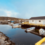
  • Brigus South - Take the left turn off Route 10 to Brigus South, and follow the road for 2 km into the community. Reaching the harbour, park on the south side, at the beach pullout. Do not block the community wharf or other local access. Proceed for 200 m to the trailhead.
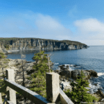
  • Admirals Cove - Upon entering Cape Broyle, look for the turnoff, left, to Admirals Cove. Drive 3.4 km along the shore, and through Admirals Cove. Park in the lot above Harveys Gulch, and proceed along Cranes Lane to the trailhead.

Community Walk Getting to Cape Broyle Head Path: After exiting the trail from the Admirals Cove trailhead, walk along Cranes Lane for 600 m, and then follow Admirals Cove Road and Shores Cove Road for 3.5 km to Route 10. After 100 m, turn left and follow Lower Road (Harbour Road) through Cape Broyle for 1.4 km. At the post office, turn left onto Ferry Pond Road. After 250 m, the road takes a sharp right and proceeds another 250 m to Route 10. Follow the highway across the bridge, and turn onto Southside Road. Proceed to the end of the road (800 m). Continue down to the beach (100 m) and the Cape Broyle Head Path trailhead (total: 7.8 km).
Amenities
Parking
Features
Beach
Bog
Cart Track
Cliff
Developed Trail
Gulch
Gully
Historic Site
Island View
Meadow
Ridge
Woodland