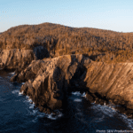

Access Points:
- Aquaforte - From Route 10, exit at the Aquaforte Community Hall (white building). Continue to a fork in road and keep to the right. Park on either the south side of Loop Road, near the Island, or the south side of Riverhead Road. Do not block local access. The path begins at the end of Riverhead Road.
- South West River – park in the designated parking area adjacent to the river at the south end of Aquaforte.
- Port Kirwan - From Route 10 at Fermeuse, turn east and continue approximately 5 km to Port Kirwan. Park at the Mike Shallow Community Centre. The trailhead is located immediately past Immaculate Conception church.
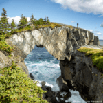
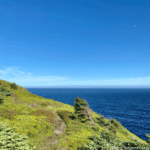
Camping: Wilderness camping is available at Gallows Cove Campsite, 11.2 km from the Aquaforte trailhead. No reservations required. The campsite includes four tent platforms and an outdoor, primitive toilet. Be sure to carry a camp stove, as open fires are not permitted.
Community Walk Getting to Bear Cove Point Path: After exiting the trail from the Port Kirwan trailhead, follow Port Kirwan Road for 4.5 km to the junction with Route 10. Follow the highway for 350 m and turn left onto Lumley Cove Road. Follow this road for 800 m to Brophy's Road, Brophy's Road to the "Corkscrew" (200 m), and the "Corkscrew" to Kingman's Cove Road (200 m). Follow Kingman's Cove Road left for 1.3 km to Kingman's Cove and the Bear Cove Point Path trailhead (total: 7.4 km).